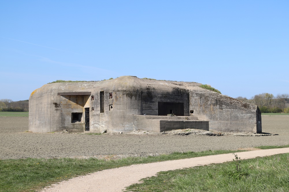
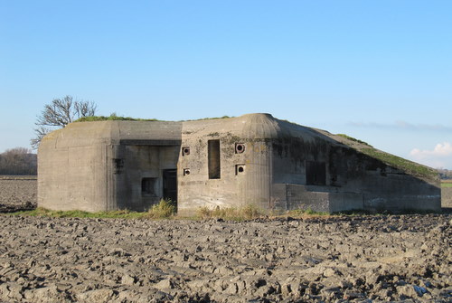
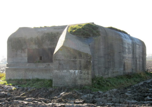
Landfront Vlissingen - Stützpunkt Kolberg - Bunker 4 type 623

The following text can be read on the information board of the Bunker Preservation Foundation:
First of all, general information about the Landfront Vlissingen.
Landfront Vlissingen
Vlissingen was an important position during World War II and was strongly fortified as part of the German defense line "Atlantikwall". To protect the fortress against attacks from the rear, a defensive belt was constructed on the landward side of the city. This so-called Landfront consisted of a kilometer-long anti-tank ditch with dozens of casemates for machine gun and anti-tank gun behind it. The line started in the west in the dunes of Groot-Valkenisse and ran across Koudekerke to the Canal through Walcheren. On the eastern side of the canal, the Landfront continued its way towards Ritthem, where the line in the Schorerpolder ended at Fort Rammekens. Most of the Landfront has been preserved.
After the above general information, the following text can be read on the information board at Bunkers 3, 4 and 5.
The text:
The Land Front during the battle in November 1944.
In November 1944, the Allied troops landed on Walcheren in order to break the last German resistance in the southwest of the Netherlands and to clear access to the port of Antwerp. At that time, despite all the energy that had been put into construction, the line was not finished and there were still plans for additional machine-gun casemates.
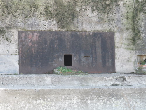
Yet the line, together with the artillery batteries behind it, posed such a threat to the landing units that partly for this purpose it was decided to turn off the defenses by flooding the island. In October 1944 the dikes and dunes on Walcheren were bombed in four places after which the island was slowly submerged. The Germans tried to preserve the casemates and bunkers for as long as possible by protecting them from seawater. To this end, the entrances, gun openings and air intakes were bricked up higher and higher. Ultimately, this did not help much and the casemates had to be considered lost. These emergency measures can be clearly seen at various Landfront bunkers today. The barnacles on the bunker walls also clearly show that the island has been under water for a long time.
The photos of bunker 4 are taken from the path that runs along bunkers 3, 4 and 5 because these bunkers are on agricultural land and cannot be visited otherwise. This path has been specially constructed to create a bunker route on the initiative of the Bunker Preservation Foundation so that as many bunkers as possible can be viewed up close during a tourist cycling / walking route.
Below is a call from the Bunker Preservation Foundation, which TracesOfWar has joined.
Please:
Many bunkers on Walcheren and the Bevelanden are on private land. The dunes are off limits, please ask for permission before viewing a bunker. Please also note that for many owners Sunday is a day of rest. Do not cause any inconvenience.
Do you have more information about this location? Inform us!
Source
- Text: Mia van den Berg / Stichting Bunkerbehoud
- Photos: Jeroen Koppes (1), Mia van den Berg (2, 3, 4)

Nearby
Museum
- Stützpunkt Lohengrin - Bunkermuseum Zoutelande bunkertype 143 - Zoutelande
- Stützpunkt Lohengrin - Bunkermuseum Zoutelande bunkertype 502 - Zoutelande
- Keizersbolwerk Vlissingen - Vlissingen
Point of interest
- Information Sign The Battle of Dishoek - Dishoek
- ‘Der Boede’ Estate - Koudekerke
- Castle Ter Hooge - Middelburg
Monument
- War Memorial Koudekerke - Koudekerke
- Memorial 47th Royal Marines Commando Dishoek - Dishoek
- Memorial 47 Royal Marine Commando - Dishoek
Cemetery
- Commonwealth War Grave General Cemetery Zoutelande - Zoutelande
- Commonwealth War Graves Flushing (Vlissingen) - Vlissingen
- Dutch War Graves (Noorderbegraafplaats) - Vlissingen
Remembrance Stone
- Stumbling Stones Park de Griffioen 22 - Middelburg
- Stumbling Stones Park de Griffioen 10 - Middelburg
- Stumbling Stones Park de Griffioen 2 - Middelburg
Fortification
- Landfront Vlissingen - Stützpunkt Kolberg - Bunker 3 type 623 - Koudekerke
- Landfront Vlissingen - Stützpunkt Kolberg - Bunker 5 type 623 - Koudekerke
- Landfront Vlissingen - Stützpunkt Kolberg - Bunker 1 type 631 - Koudekerke
Crash site
Looking for reliable information or news facts about WW2? Do you want to create your own battlefield tour to sights of wars from the past? Or are you interested in war medals and their recipients? TracesOfWar.com tells you more!
More information

© STIWOT, 1999-2025. All rights reserved. Privacy statement, cookies, disclaimer and copyright