Info Board Landmark of the Landings

Info board with the following text:
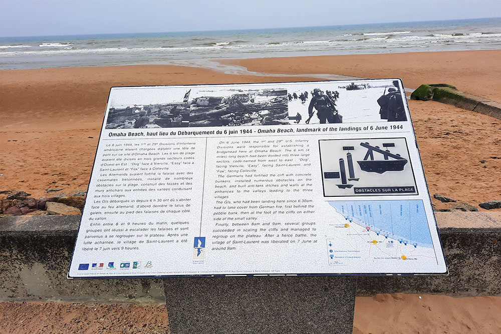
On 6 June 1944, the 1st and 29th U.S. Infantry Divisions ons were responsible for establishing a bridgehead here at Omaha Beach. The 6 km (4) miles) long beach had been divided into three large sectors, code-named from wes to east "Dog", facing Vierville, "Easy", facing Saint-Laurent, and "Fox", facing Colleville.
The Germans had fortified the cliff with concrete bunkers, installed numerous obstacles on the beach, and built anti-tank ditches and walls at the entrances to the valleys leading to the three villages.
The Gls, who had been landing here since 6.30am, had to take cover from German fire, first behind the pebble bank, then at the foot of the cliffs on either side of the small valley
Finally, between 8am and 9am, several groups succeeded in scaling the cliffs and managed to regroup on the plateau. After a fierce battle, the village of Saint-Laurent was liberated on 7 June at around 9am.
Do you have more information about this location? Inform us!
Source
- Text: TracesOfWar
- Photos: Koos Winkelman
Related books


Nearby
Museum
- Omaha Beach Memorial Museum - Saint-Laurent-sur-Mer
- Musée D-Day Omaha - Vierville-sur-Mer
- Normandy American Cemetery & Memorial Visitors Centre - Colleville-sur-Mer
Point of interest
- M4A4 Sherman Tank Saint-Laurent-sur-Mer - Saint-Laurent-sur-Mer
- Information Panel Saint-Laurent-Sur-Mer - Saint-Laurent-sur-Mer
- Info Board Vierville-sur-Mer - Vierville-sur-Mer
Monument
- Memorial Omaha Beach - Saint-Laurent-sur-Mer
- Les Braves Omaha Beach Memorial - Saint-Laurent-sur-Mer
- Memorial Operation Aquatint - Saint-Laurent-sur-Mer
Cemetery
- Commonwealth War Graves Saint-Laurent-sur-Mer - Saint-Laurent-sur-Mer
- Normandy American Cemetery and Memorial - Colleville-sur-Mer
- Commonwealth War Grave Colleville-sur-Mer - Colleville-sur-Mer
Fortification
Looking for reliable information or news facts about WW2? Do you want to create your own battlefield tour to sights of wars from the past? Or are you interested in war medals and their recipients? TracesOfWar.com tells you more!
More information

© STIWOT, 1999-2025. All rights reserved. Privacy statement, cookies, disclaimer and copyright