D-Day, 6 June, 1944, a most important date where the liberation of Europe is concerned. On this day the largest amphibious landing in history took place on the continent. During Operation Overlord allied soldiers set foot on French territory. The target was breaking through Hitler’s Atlantikwall. By following this route you will pay a one-day-visit to the most important places of interest in the sector of the British airborne operation and Sword Beach on D-Day.
Introduction
In the spring of 1943 the allied planners of the invasion, under the command of Lieutenant-General Frederick Morgan, had selected Normandy as the spot for the invasion of Western Europe. A landing on the beaches of Normandy however had an important set back: the allied left flank was very vulnerable for counter attacks. The strongest German units in France, especially armoured divisions, were to be found between Le Havre and the mouth of the river Seine, as the Germans expected the allied invasion to take place at the Straits of Dover.
In case Generalfeldmarschall Erwin Rommel, who was in charge of the units along the French coast, succeeded in taking his troops and tanks across the rivers Seine, Dives and Orne he would be able to fold up all troops on the invasion beaches one by one, from Sword Beach to Utah Beach. Because it would cost the allies several days to establish a force, sufficiently strong with tanks and artillery, to defeat a heavy German counter attack.
Morgan and his staff decided that the British 6th Airborne Division would be dropped between the river Dives and the waterways of the Orne in order to protect this vulnerable left flank. The 6th Airborne Division was one of two airborne divisions of the British army and the division stood under command of Major-General Richard Gale. Almost immediately upon its creation, the task of the division during D-Day was set. After General Dwight Eisenhower took over the responsibility of allied supreme commander in January 1944 from Morgan, an important number of aspects of the invasion plan were adjusted. The part of the 6th Airborne Division however remained as it was.
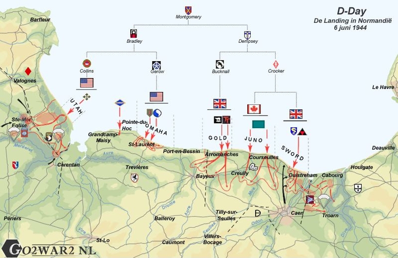
Overview of the landing locations on D-Day. Source: Peter Boellaard.
Sword Beach
Sword Beach, seen from the allied point of view, was the utmost left of the five invasion beaches. Sword Beach comprised the coast between the villages of St.Aubin-sur-Mer and Ouistreham, at the mouth of the river Orne. The British 3rd Infantry Division, under the command of Major-General Thomas Rennie was to land on this coastal section, supported by the 27th Armoured Brigade under the command of Brigadier G.E. Prior-Palmer. Next to these troops, also the commando forces of the 1st Special Service Brigade under Lord Simon Lovat were to land here. The British forces would have to advance in-land as quickly as possible from the beach in order to extend the bridge-head and in doing so making contact with the neighbouring Juno Beach, take the city of Caen and connect with the 6th Airborne Division at the bridge-head on the opposite bank of the river Orne.
The British airborne operation
In order to protect the vulnerable left flank the airborne troops of the 6th Airborne Division had to destroy the bridges across the rivers Dives and Divette in order to prevent the Germans using these bridges during a counter attack. The bridges across the Orne and the Canal of Caen, named by the British forces the Horsa Bridge and the Pegasus Bridge respectively, had to be taken intact as these had to be used later on by the British forces for the connection between the bridge-head of the airborne troops and Sword Beach. Apart from that, the Merville Battery had to be demolished before the landings on Sword Beach would begin, as those could direct their fire at the invasion troops on Sword Beach.
Introduction
In the spring of 1943 the allied planners of the invasion, under the command of Lieutenant-General Frederick Morgan, had selected Normandy as the spot for the invasion of Western Europe. A landing on the beaches of Normandy however had an important set back: the allied left flank was very vulnerable for counter attacks. The strongest German units in France, especially armoured divisions, were to be found between Le Havre and the mouth of the river Seine, as the Germans expected the allied invasion to take place at the Straits of Dover.
In case Generalfeldmarschall Erwin Rommel, who was in charge of the units along the French coast, succeeded in taking his troops and tanks across the rivers Seine, Dives and Orne he would be able to fold up all troops on the invasion beaches one by one, from Sword Beach to Utah Beach. Because it would cost the allies several days to establish a force, sufficiently strong with tanks and artillery, to defeat a heavy German counter attack.
Morgan and his staff decided that the British 6th Airborne Division would be dropped between the river Dives and the waterways of the Orne in order to protect this vulnerable left flank. The 6th Airborne Division was one of two airborne divisions of the British army and the division stood under command of Major-General Richard Gale. Almost immediately upon its creation, the task of the division during D-Day was set. After General Dwight Eisenhower took over the responsibility of allied supreme commander in January 1944 from Morgan, an important number of aspects of the invasion plan were adjusted. The part of the 6th Airborne Division however remained as it was.
Overview of the landing locations on D-Day. Source: Peter Boellaard.
Sword Beach
Sword Beach, seen from the allied point of view, was the utmost left of the five invasion beaches. Sword Beach comprised the coast between the villages of St.Aubin-sur-Mer and Ouistreham, at the mouth of the river Orne. The British 3rd Infantry Division, under the command of Major-General Thomas Rennie was to land on this coastal section, supported by the 27th Armoured Brigade under the command of Brigadier G.E. Prior-Palmer. Next to these troops, also the commando forces of the 1st Special Service Brigade under Lord Simon Lovat were to land here. The British forces would have to advance in-land as quickly as possible from the beach in order to extend the bridge-head and in doing so making contact with the neighbouring Juno Beach, take the city of Caen and connect with the 6th Airborne Division at the bridge-head on the opposite bank of the river Orne.
The British airborne operation
In order to protect the vulnerable left flank the airborne troops of the 6th Airborne Division had to destroy the bridges across the rivers Dives and Divette in order to prevent the Germans using these bridges during a counter attack. The bridges across the Orne and the Canal of Caen, named by the British forces the Horsa Bridge and the Pegasus Bridge respectively, had to be taken intact as these had to be used later on by the British forces for the connection between the bridge-head of the airborne troops and Sword Beach. Apart from that, the Merville Battery had to be demolished before the landings on Sword Beach would begin, as those could direct their fire at the invasion troops on Sword Beach.
| # | Punt | Bezienswaardigheid | ||||||||||||||||||||||||||||||||||||||||||||||||||||||||||||||||||||||||||||||||||||||||||||||||||
|---|---|---|---|---|---|---|---|---|---|---|---|---|---|---|---|---|---|---|---|---|---|---|---|---|---|---|---|---|---|---|---|---|---|---|---|---|---|---|---|---|---|---|---|---|---|---|---|---|---|---|---|---|---|---|---|---|---|---|---|---|---|---|---|---|---|---|---|---|---|---|---|---|---|---|---|---|---|---|---|---|---|---|---|---|---|---|---|---|---|---|---|---|---|---|---|---|---|---|---|---|
| A | Startpunt | 9th Battalion memorial stele | ||||||||||||||||||||||||||||||||||||||||||||||||||||||||||||||||||||||||||||||||||||||||||||||||||
| Location 1: The rendezvous point of 9th Parachute Battalion The actions of the 6th Airborne Division were carried out by 3rd Parachute Brigade, 5th Parachute Brigade and 6th Airlanding Brigade. The targets of the 3rd Parachute Brigade were the demolition of the four bridges over the Dives, one bridge across the Divette at Varaville and to capture the battery at Merville. The target of the 5th Parachute Brigade was the intact capturing of the Horsa Bridge and the Pegasus Bridge after which a bridge-head had to be established to defend both. The 6th Airlanding Brigade would land in the evening of the 6th of June 1944 during Operation Mallard in order to reinforce both parachute brigades. The landing of the 3rd Parachute Brigade consisting of the 9th Parachute Battalion, the 8th (Midlands) Parachute Battalion and the 1st Canadian Parachute Battalion did not proceed smoothly as heavy overcast caused navigation problems. The paratroopers of the 8th (Midlands) Parachute Battalion and the 1st Canadian Parachute Battalion got dispersed during the landing but succeeded finally to demolish the bridges at Troarn, Bures, Robbehomme and Varaville. Thereafter they moved in westerly direction in order to capture the ridge between Amfreville and Troarn and to fend off German counter attacks in the direction of the bridge-head. 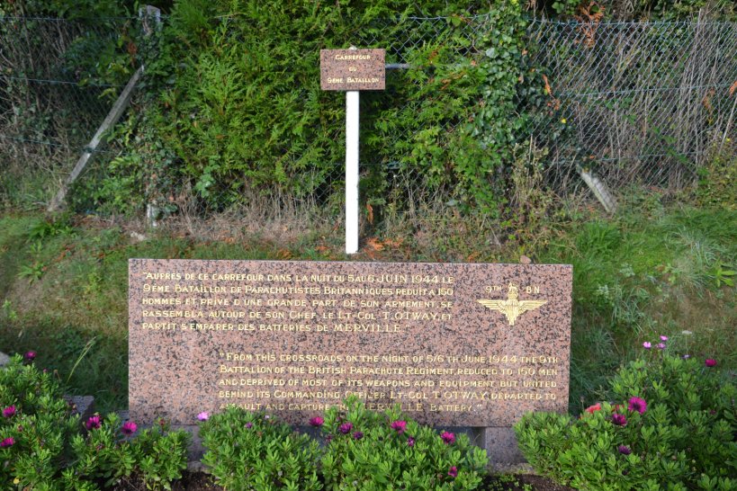 The 9th Battalion memorial stele at the rendez-vouspoint of the 9th Parachute Battalion. Photo: Peter Bijster. The 600 paras of the 9th Parachute Battalion were also scattered during the landing. After the troops had left the dropzone they advanced towards this crossroads about 2 kilometres east from the battery. Here they were informed by a reconnaissance group of the battalion that had jumped before the main force and had to confirm the German presence in the battery. After they had checked their weapons, the men that had come together in time, left for the battery. It was 04:00 in the early morning of June 6th. The text on the memorial reads in French and English: "From this crossroads on the night of 5/6th June 1944 the 9th Battalion of the British Parachute Regiment reduced to 150 men and deprived of most of its weapons and equipment but united behind its commanding officer Lt-Col T Otway departed to assault and capture the Merville Battery." | ||||||||||||||||||||||||||||||||||||||||||||||||||||||||||||||||||||||||||||||||||||||||||||||||||||
| B | Waypoint | Atlantikwall - Museé de la Batterie de Merville | ||||||||||||||||||||||||||||||||||||||||||||||||||||||||||||||||||||||||||||||||||||||||||||||||||
| Location 2: The Merville Battery The battery of Merville consisted of 4 gun emplacement casemates, a command bunker, a crew bunker and various ammunition bunkers. According to the allied intelligence the gun emplacements were equipped with 150mm guns which could cover Sword Beach. The close up defences of the battery consisted of 20mm anti-aircraft guns, machine gun pits, two barbed wire barriers and a mine field. 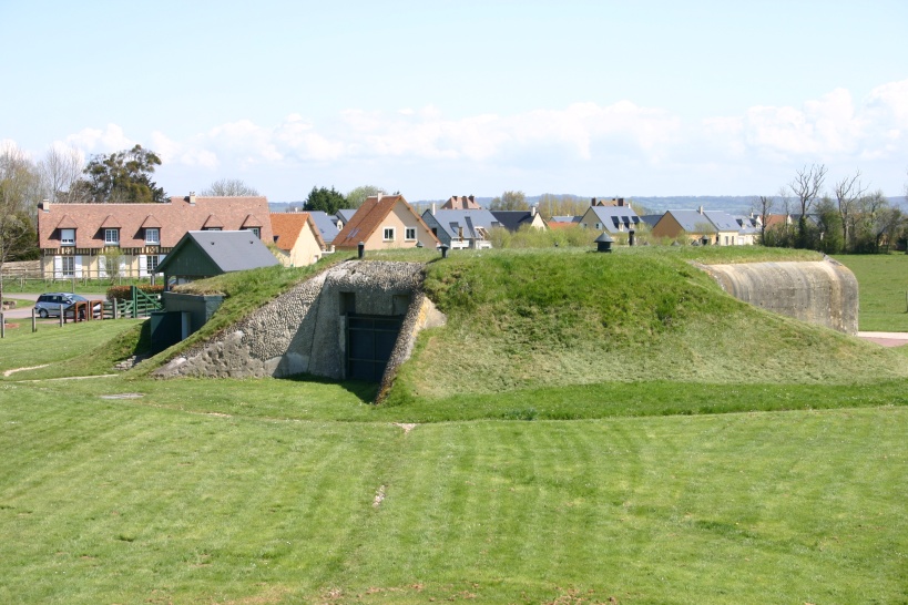 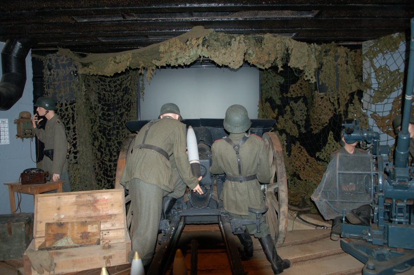 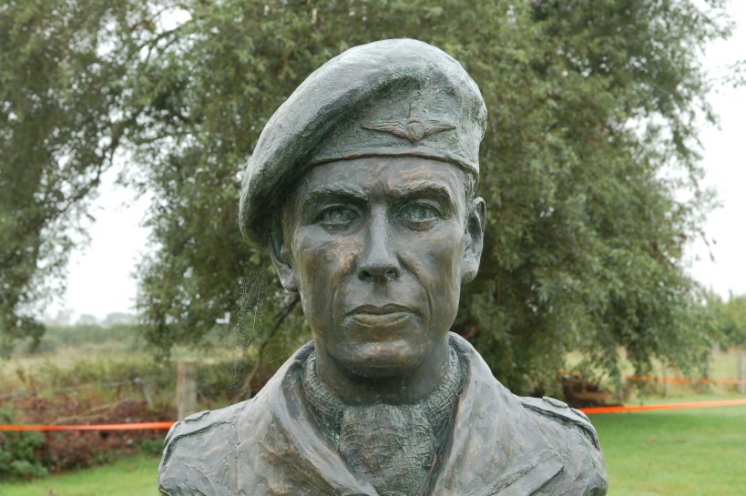 One of the gun emplacement casemates at the Merville Battery, the interior of one of the gun emplacement casemates and the bust of Lieutenant-Colonel Terence Otway. Photos: Jeroen Koppes (1), Peter Bijster (2) and Barry van Veen (3). The attack on the battery of Merville had been extensively practiced by the 9th Parachute Battalion in England. For these exercises a life size mock-up of this battery had been built on which no less than 9 attacks were carried out, both in daylight and in nocturnal darkness. The actual attack would be preceded by a bomb raid by 100 Lancaster bombers. After the raid, the battery would be attacked by the 600 paras of Otway and next to that, 60 men would land in the middle of the battery by means of three gliders. The situation on the ground in France however differed from the one in England. Not only did Otway have only 150 men at his disposal with only one machine gun and 20 Bangalore torpedoes, also the bombing raid by the Lancasters had ended in a disaster and he had no mortar flares in order to signal the flight crews of the gliders where to land. One glider had already landed beforehand in England because of technical problems, but when the two remaining gliders appeared over the battery, no signal from the ground was received which prevented the pilots from landing inside the fenced battery. At that moment Otway on the ground had already decided to run a frontal attack on the battery with all his paras. The paratroopers stormed shooting and shouting at the German defenders and succeeded in overrunning them The bunkers were eliminated by firing into the gun ports and throwing hand grenades inside. The whole of the attack did not last more than twenty minutes. Of the 150 paras more than half was left dead or wounded after the attack. The remaining paratroopers quickly left for their next assignment, the capturing of the ridge between Amfreville and Troarn. | ||||||||||||||||||||||||||||||||||||||||||||||||||||||||||||||||||||||||||||||||||||||||||||||||||||
| C | Waypoint | No. 4 Commando stele | ||||||||||||||||||||||||||||||||||||||||||||||||||||||||||||||||||||||||||||||||||||||||||||||||||
| Location 3: No. 4 Commando stele at the ridge This memorial has been erected in memory of No.4 Commando. If you follow the dirt road on the left hand side of the memorial you will find after some 200 yards an information table on the right hand side of the path. The location of the panel provides a beautiful view over Sword Beach and the Orne valley where the Horsa Bridge and the Pegasus Bridge are located. From here you will easily be able to judge the strategic value of the hard fought battle for the ridge between Amfreville and Troarn. After the elimination of the battery of Merville the 9th Parachute Battalion had orders to take positions in the village of Amfreville on this ridge. Otway left with only 80 paras to the village. On their way to Amfreville the number of paratroopers increased slightly with several lost paras they picked up en route. Arriving at Amfreville it appeared that in neighbouring hamlet Le Plein the headquarters of Ostbataljon 642 had been established. The Ostbataljon was a unit which consisted mainly of former soldiers from the Red Army. The village was heavily defended by these troops. After some attacks from both sides Otway drew the conclusion that his battalion had been too much reduced in strength to capture Le Plein and to hold it also afterwards. Otway decided therefore to withdraw to Château d’Amfreville in order to await the arrival of the 1st Special Service Brigade. Around 18:00 on the 6th of June 1944 No.3 Command reached Château d’Amfreville and succeeded to relieve the, in the meantime surrounded, paras. 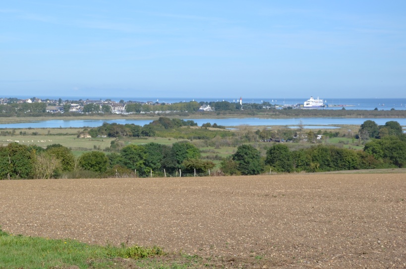 The view on the estuary of the River Orne, Ouistreham and Sword Beach from the ridge. Photo: Peter Bijster. The ruins of the Château d’Amfreville are situated in the fringes of the woods about 200 yards south-east of your position and can be reached on foot. You also can continue to drive to the parking lot at the Rue de la Culture in Amfreville from where you can easily reach the ruins of the Château d’Amfreville and the still existing church of Saint Martin at Le Plein by foot. | ||||||||||||||||||||||||||||||||||||||||||||||||||||||||||||||||||||||||||||||||||||||||||||||||||||
| D | Waypoint | Commonwealth War Cemetery Ranville | ||||||||||||||||||||||||||||||||||||||||||||||||||||||||||||||||||||||||||||||||||||||||||||||||||
| Location 4: Commonwealth War Cemetery Ranville The Commonwealth War Cemetery Ranville is situated right in the middle of the operational theatre of the 6th Airborne Division. On the cemetery 2,235 killed-in-action from the Commonwealth have been buried of whom 97 have not been identified. Many of them are airlanding troops of the 6th Airborne Division. Also buried in this cemetery are a number of allied soldiers form other nationalities, as well as 330 Germans. On several locations in this part of the operational area during and immediately after the fighting smaller cemeteries were established, close by the spot where the men fell. After the fighting many of these graves from amongst others Amfreville, Colleville-Montgomery, Houlgate, Colombelles and Villers-sur-Mer were assembled here. On the cemetery there are many special graves. For example you will find here the grave of R.J. Johns, with 16 years the youngest killed British para in the Second World War. The brothers J. Maurice Rousseau and J. Philippe Rousseau of the 1st Canadian Parachute Battalion have been buried here side by side. Also here lie buried E.S. Corteil of the 9th Parachute Battalion together with his para-dog Glenn. Glenn was the mascot of the 9th Parachute Battalion. 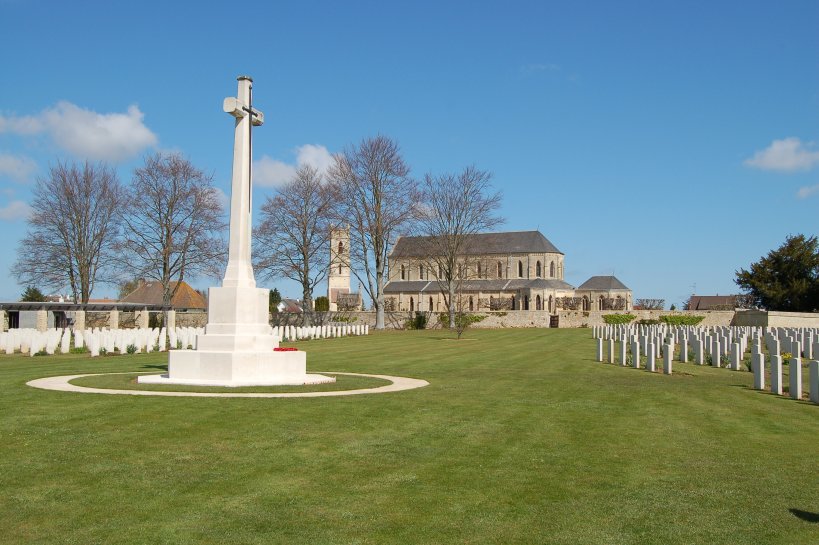 The Commonwealth War Cemetery Ranville with the church of Ranville in the background. Photo: Barry van Veen. Next to the cemetery there is the magnificent church of Ranville with the belonging graveyard where again 47 killed from the Commonwealth and one German soldier have been buried. On the graveyard there is also the grave of Den Brotheridge. Brotheridge is seen by many to be the first allied soldier killed on D-Day. He landed with his glider at 00:16 at the Pegasus Bridge and at the first assault across the bridge he was wounded after which he succumbed. | ||||||||||||||||||||||||||||||||||||||||||||||||||||||||||||||||||||||||||||||||||||||||||||||||||||
| E | Waypoint | Pegasus Bridge | ||||||||||||||||||||||||||||||||||||||||||||||||||||||||||||||||||||||||||||||||||||||||||||||||||
| Location 5: The Pegasus Bridge and the Memorial Pegasus The bridges across the river Orne and the Canal of Caen, named by the British forces the Horsa Bridge and the Pegasus Bridge respectively, had to be captured intact as those bridges had to be used by the British forces later on. If they were not captured, they formed also a barrier between the infantry on the landing beach and the airlanding troops of the 6th Airborne Division. The D-company and 2 platoons of B-company of the 2nd Oxfordshire and Buckinhamshire Light Infantry had been selected to carry out the attack. This unit stood under the command of Major John Howard. Six gliders, towed by Halifax bombers, with one platoon in each plane, left in the evening of June 5th towards 23:00 from RAF airfield Tarrant Rushton in Hampshire in the south of England. Before departure almost everybody had shaken hands saying: "See you at the bridge!" When the formation reached the French coast the gliders detached from the bombers. These continued onwards to bomb Caen which was rather a distraction manoeuvre than a serious attack. The landing of the first glider was rough and launched the two pilots through the cockpit windows which rendered them unconscious. Yet they had landed exactly on the spot that had been selected. Air Chief Marshall Leigh-Mallory called this fact the very best demonstration of airmanship in the war. The German guard on the bridge heard the crash but assumed that it was a piece of wreckage from a bomber, something that had occurred before. Quickly Den Brotheridge stormed across the bridge followed by his men. The guards started to run, while from two machine gun posts fire was opened. Brotheridge threw one grenade which annihilated one of the machine gun posts before he himself was hit. Billy Gray annihilated the other machine gun post with his Bren gun. The engineers immediately had started to remove the demolition charges and to cut the connecting wiring. Another team had succeeded in eliminating the bunker. The Pegasus Bridge had been captured. About four hundred yards further on Captain Priday’s men in the meantime had taken possession of the Horsa Bridge. Howard could now instruct his radio operator to signal his victory code "Ham and Jam". Together with the blowing up of the bridges across the Dives and Divette rivers, the conquest of the battery of Merville and the occupation of the ridge, the British 6th Airborne Division had reached all targets within the set timescale. Now the bridges had to be held until Lord Lovat and his commandos would arrive from Sword Beach. 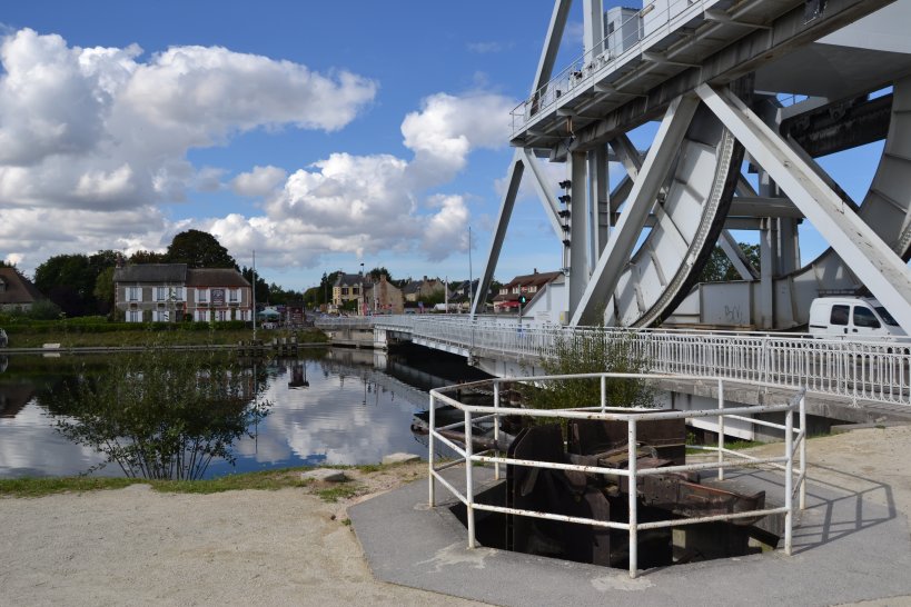 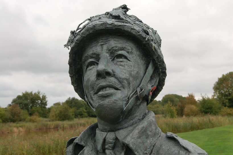  The new Pegasus Bridge over the Caen Canal with Cafe Gondrée in the background, the bust of Major John Howard and the replica of a Horsa glider at the Memorial Pegasus. Photos: Peter Bijster (1) and Barry van Veen (2) (3). In 1993 the original Pegasus Bridge was replaced by a new one which is less obstructive for professional shipping. The old bridge however can be found at the Memorial Pegasus, the museum dedicated to the men of the 6th Airborne Division and their heroic behaviour in the night of 5 to 6 June 1944 and its successive days. Close to the bridge you also find ‘Café Gondree’, the first house in occupied France that was liberated during D-Day and still is a pub full of souvenirs. | ||||||||||||||||||||||||||||||||||||||||||||||||||||||||||||||||||||||||||||||||||||||||||||||||||||
| F | Waypoint | Memorial Piper Bill Millin | ||||||||||||||||||||||||||||||||||||||||||||||||||||||||||||||||||||||||||||||||||||||||||||||||||
| Location 6: Piper Bill Millin Memorial on Sword Beach. Now the moment had arrived for the landings on Sword beach. Here, the British 3rd Infantry Division, the 27th Armoured Brigade and commando troops of the 1st Special Services Brigade would step ashore. According to the scrupulous planning the DD tanks of the 27th Armoured Brigade had to spearhead the landing. The sea state however was so rough that the tanks could only be launched about 5 kilometres from the coast, instead of the originally planned 8 kilometres. The tanks had enormous problems in making any progress in the water and were soon bypassed by the landing craft with infantry. The first LCAs and LCTs ran ashore just after the expiration of H Hour. Frogmen jumped over the sides of their craft into the water and started demolition work of obstacles. The infantry left their boats and waded towards the beach. They were shelled with machine gun and mortar fire. As a consequence of this barrage the British forces suffered heavy losses and a number of soldiers got into shock. Still a large number of soldiers succeeded in crossing the beach and to direct fire at the German defenders. The Sherman and Churchill tanks appeared to be of great value in shooting at the Germans. With their .50 machine guns and their canons they provided the fire support to the British troops which the Americans on Omaha Beach missed so dearly. They also provided welcome cover for the troops that still had to cross the sand. 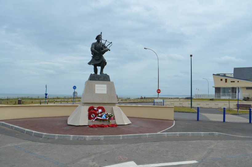 Piper Bill Millin Memorial with Sword Beach in the background. Photo: Jeroen Niels. In spite of the fact that the first landings on Sword Beach were relatively successful not all planned targets were met. The attacking troops were not able to push through to the hinterland immediately, they were delayed by precision fire of machine guns and mortars and sharp shooters. The Lovat commandos ran a bit behind schedule by these delays. With piper Bill Millin at the head of the column, the troops started to advance towards the Pegasus Bridge. Around 13:00 the airlanding troops at the bridge heard the sound of the bagpipe of Bill Millin. This was answered by two blasts on the bugle. Lovat and his commandos, followed by a Churchill tank marched in the direction of the bridges. The British airlanding troops had in fact complied with their tasks now the contact with their bridge-head had been established. They had conquered the bridges and held them until they would be relieved. | ||||||||||||||||||||||||||||||||||||||||||||||||||||||||||||||||||||||||||||||||||||||||||||||||||||
| G | Waypoint | Atlantikwall - Hillman Bunker | ||||||||||||||||||||||||||||||||||||||||||||||||||||||||||||||||||||||||||||||||||||||||||||||||||
| Location 7: Widerstandsnest 17, codename Hillman Before midnight many more men had stepped ashore on Sword Beach and contact had been made with the 6th British Airborne Division. The estimated losses during the landing were 630 killed and wounded. On German side the losses were terribly high. The 716. Infanteriedivision was completely annihilated. They were either killed or made prisoner. Yet the landing on Sword Beach was not fully successful especially the advance in-land. Caen had not been captured and on the right hand flank it had not been possible to make contact with the Canadians on Juno Beach. The British advance in-land had been seriously delayed by the conquering of two German reinforced fortresses with the codenames Hillman and Morris. Morris consisted of four gun emplacements for 100mm guns and was attacked around 13:00 and quickly captured by the 1st Battalion The Suffolk Regiment. After Morris they prepared for the attack on Hillman which consisted of eighteen underground bunkers and a number of tobruks. Hillman was the nerve centre from which the German defences of the area were commandeered. From here you have a beautiful view on the whole of the coastal area of Sword Beach. The first attack on Hillman by the 1st Battalion The Suffolk Regiment was countered by the German defenders. The second attack was carried out after a lot of delays with the support of Sherman tanks of the 13/18th Hussars and was only successful after a 6 hour battle. Around midnight the command post was conquered and 40 Germans were made prisoner. The delay in the capturing of Hillman however was the reason German units bought the time necessary to establish the defences of Caen.  The interior of one of the bunkers of Widerstandsnest 17 as can be seen during one of the guided tours. Photo: Peter Bijster. Without Hillman maybe Caen would have fallen in the hands of the allies within a matter of days instead of several weeks. Today Hillman is managed by the foundation "Les amis du Suffolk Regiment" Its visit is free of charge and between July and September guided tours are conducted and the interior of the bunkers can be visited. | ||||||||||||||||||||||||||||||||||||||||||||||||||||||||||||||||||||||||||||||||||||||||||||||||||||
| H | Eindpunt | Point 55 | ||||||||||||||||||||||||||||||||||||||||||||||||||||||||||||||||||||||||||||||||||||||||||||||||||
| Location 8: Point 55 on the Périers Ridge The last location of this tour is Point 55 , the highest point of the road on the Périers Ridge which is situated between Périers-sur-le-Dan and Plumetot. On the maps of the allied forces this point was marked as "Point 55". In the afternoon of the 6th of June, 1994, units of the 21. Deutsche Panzer-Division jumped into this gap between the British forces on Sword Beach and the Canadian forces on Juno Beach.  The view on Sword Beach and the hinterland from Point 55 on the Périers Ridge. Photo: Peter Bijster. The German combat group consisted of approximately 40 tanks with supporting units. Around 16:00 the battle force arrived at the Périers Ridge. At that moment there were also present British troops of the King’s Shropshire Light Infantry, tanks of the Staffordshire Yeomanry and tank destroyers of the 41st Anti-Tank Battery, Royal Artillery. The British forces were composed much more balanced and apart from that, they received air support by fighter planes. The Germans therefore suffered heavy losses during the fighting in that area. In spite of these heavy losses they advanced up to the village of Lion-sur-Mer. While they were fired at by allied anti-tank guns small German units even succeeded in reaching the beach at Lion-sur-Mer around 19:30. With the fear of becoming surrounded by the arrival of the air fleet carrying out Operation Mallard the penetrating German troops however quickly withdrew. The only German counter attack on D-Day was fended off. It would become the last time the Germans succeeded in reaching the coast. For the British forces, D-Day was a success, in spite of the fact that Caen had not been liberated. Text Source: Pieter Schlebaum, Jeroen Niels and Barry van Veen Photo source: Peter Bijster, Jeroen Koppes, Jeroen Niels and Barry van Veen Translation: Fred Bolle | ||||||||||||||||||||||||||||||||||||||||||||||||||||||||||||||||||||||||||||||||||||||||||||||||||||
Looking for reliable information or news facts about WW2? Do you want to create your own battlefield tour to sights of wars from the past? Or are you interested in war medals and their recipients? TracesOfWar.com tells you more!
More information

© STIWOT, 1999-2025. All rights reserved. Privacy statement, cookies, disclaimer and copyright