D-Day, 6 June, 1944, a most important date where the liberation of Europe is concerned. On this day the largest amphibious landing in history took place on the continent. During Operation Overlord allied soldiers set foot on French territory. The target was breaking through Hitler’s Atlantikwall. By following this route you will pay a one-day-visit to the most important places of interest on Juno, Gold and Omaha beach on D-Day.
Juno Beach
Juno Beach was in the middle of the three British/Canadian invasion beaches which were attacked by the 2nd British Army, commanded by General Sir Miles Dempsey. Seen from the allied point of view the beach bordered on its right hand flank on Gold Beach and Sword Beach was to its left. It covered 7 kilometers of coastline between Graye-sur-Mer and St.Aubin-sur-Mer, and was split in the middle by the river Seulles which flows into the sea here.
Gold Beach
Gold Beach was in the middle of the five invasion beaches and the most westerly of the British/Canadian beaches which would be attacked by the 2nd British Army, commanded by General Sir Miles Dempsey. The German defenses on Gold Beach were often placed in the holiday houses which were spread over the coastal area. In 1943 a powerful coastal battery had been constructed on the cliffs near Longues-sur-Mer, between Gold and Omaha.
Omaha Beach
The American troops that landed on D-Day did this on the two beaches situated to the far right hand side, seen from the allied point of view, called Utah and Omaha. Utah was the far right hand beach, left of it was Omaha Beach and Pointe du Hoc was situated in between those two American landing beaches. Omaha, the place after which Omaha Beach was named, is a little town at the river Missouri in Nebraska in the USA. On this beach the first landing wave would be existing of 2 divisions, the 1st and the 29th Infantry Division.
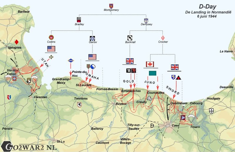
Overview of the landing locations on D-Day. Source: Peter Boellaard.
Juno Beach
Juno Beach was in the middle of the three British/Canadian invasion beaches which were attacked by the 2nd British Army, commanded by General Sir Miles Dempsey. Seen from the allied point of view the beach bordered on its right hand flank on Gold Beach and Sword Beach was to its left. It covered 7 kilometers of coastline between Graye-sur-Mer and St.Aubin-sur-Mer, and was split in the middle by the river Seulles which flows into the sea here.
Gold Beach
Gold Beach was in the middle of the five invasion beaches and the most westerly of the British/Canadian beaches which would be attacked by the 2nd British Army, commanded by General Sir Miles Dempsey. The German defenses on Gold Beach were often placed in the holiday houses which were spread over the coastal area. In 1943 a powerful coastal battery had been constructed on the cliffs near Longues-sur-Mer, between Gold and Omaha.
Omaha Beach
The American troops that landed on D-Day did this on the two beaches situated to the far right hand side, seen from the allied point of view, called Utah and Omaha. Utah was the far right hand beach, left of it was Omaha Beach and Pointe du Hoc was situated in between those two American landing beaches. Omaha, the place after which Omaha Beach was named, is a little town at the river Missouri in Nebraska in the USA. On this beach the first landing wave would be existing of 2 divisions, the 1st and the 29th Infantry Division.
Overview of the landing locations on D-Day. Source: Peter Boellaard.
| # | Punt | Bezienswaardigheid | ||||||||||||||||||||||||||||||||||||||||||||||||||||||||||||||||||||||||||||||||||||||||||||||||||
|---|---|---|---|---|---|---|---|---|---|---|---|---|---|---|---|---|---|---|---|---|---|---|---|---|---|---|---|---|---|---|---|---|---|---|---|---|---|---|---|---|---|---|---|---|---|---|---|---|---|---|---|---|---|---|---|---|---|---|---|---|---|---|---|---|---|---|---|---|---|---|---|---|---|---|---|---|---|---|---|---|---|---|---|---|---|---|---|---|---|---|---|---|---|---|---|---|---|---|---|---|
| A | Startpunt | Centre Juno Beach | ||||||||||||||||||||||||||||||||||||||||||||||||||||||||||||||||||||||||||||||||||||||||||||||||||
| The Centre Juno Beach on Juno Beach The Canadian 3rd Infantry Division had been appointed to land on Juno Beach. The largest part of the men were of British descent and spoke English, but there were also units which consisted of French speaking Canadians (Le Régiment de Maisonneuve, Les Fulsiliers Mont-Royal, Régiment de la Chaudière). The commander of the division, General Major Rod Keller was borne in Great Britain himself. Through the Kriegsmarine the coast at Juno Beach was not as well defended as other places in Normandy or at the Straits of Dover. According to the German Navy a landing on this beach was too difficult because of the rocks and cliffs in the water. Yet barricades and defenses had been constructed. When the landing craft approached the beach they were hardly fired at, the German gun emplacements along the coast were aiming at the beach itself. Only at the moment the Canadians had approached till within a few hundred yards, the Germans could and would open fire at them. Losses were heavy. With tanks, that had reached the coast, the German defenses could be annihilated. With hindsight the Canadian troops judged the support by armored weapons as being indispensable. Those infantry troops that still were alive, looked for cover behind the tanks and tried in that way to reach the sea wall. After the crossing of the sea wall reinforced villages like Reviers, Bernières, St.Aubin and Courseulles had to be captured. Some villages were quickly captured thanks to close cooperation between tanks and infantry, in other places this was less simple. The planning for the advance in-land was quite soon in a mess, caused by a pile up of vehicles. The narrow exits from the beach caused a slow progress of the troops and their material, and so the German snipers and artillery could inflict a lot of damage. The whole day long all landing units would suffer from this, which made the targets of D-Day almost impossible to be realized. Yet one unit achieved its target. The group succeeded to occupy the railway line Caen-Bayeux. In total 14,000 men had landed on Juno Beach during D-Day. 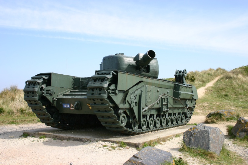 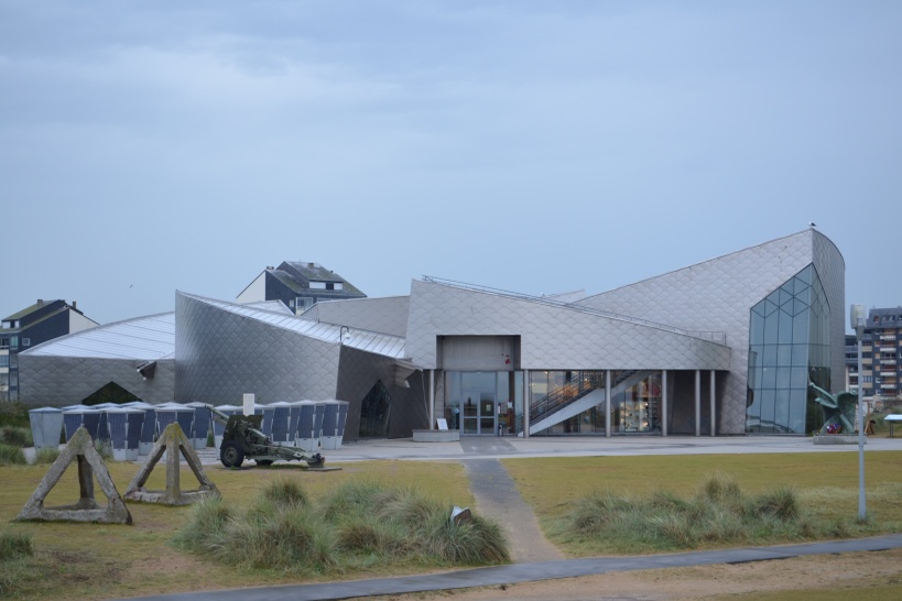 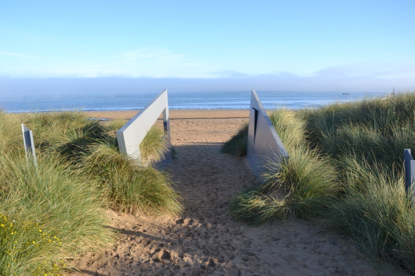 One of the indispensable tanks. The ‘Centre Juno Beach’ is as beautiful from the outside as from the inside and the view at the beach as seen from a landing craft. Pictures: Jeroen Koppes (1), Jeroen Niels (2) and Peter Bijster (3). The Centre Juno Beach is situated near the beach and memorizes the Canadian liberators. When they returned to Normandy in 1994 for the 50-years’ anniversary it appeared that there was no place for them in the Normandy museum landscape. Thanks to the efforts of the veterans themselves, fortunately this was repaired before the 60-years’ anniversary in 2004. A very interesting museum about D-Day and Canadian history with a marvelous movie as a conclusion. | ||||||||||||||||||||||||||||||||||||||||||||||||||||||||||||||||||||||||||||||||||||||||||||||||||||
| B | Waypoint | Memorial Royal Engineers | ||||||||||||||||||||||||||||||||||||||||||||||||||||||||||||||||||||||||||||||||||||||||||||||||||
| Gold Beach and the artificial harbor at Arromanches The first landing wave on Gold Beach would, just like on the British and Canadian beaches, land one hour later than the first landing wave on the American beaches. This extra hour was well utilized by the British for complimentary bombardments by the navy and air force on German reinforcements along the coast. These defenses on Gold Beach were often placed in the holiday houses which were spread over the coastal area. Contrary to the concrete bunkers on many of the other landing beaches, these holiday houses were easily destroyed by the bombardment of the navy and air force. During the landings however an important complication arose. The wind from the north-west at Gold Beach headed almost perpendicularly at the coastline which caused the water to be propelled to such height that the German obstructions were partly flooded during the first wave. Over 20 landing craft were lightly to seriously damaged which caused many losses of lives and tanks. The men and tanks of the 50th Northumbrian Infantry Division and the 8th Armoured Brigade who did land, succeeded in turning the battle quickly into their favor thanks to Hobart’s Funnies. The most important task now would be the capture of Arromanches; they succeeded around ten thirty in the evening. Here one of the two artificial harbors of the allies had to be installed. The remains of this artificial harbor can still clearly be seen today. 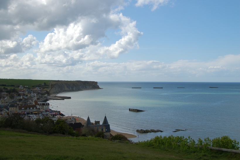 View over Arromanches and the remains of Mulberry B. Photo: Barry van Veen. The code name for the two artificial harbors which would be placed in front of the Normandy coast was Mulberry. Mulberry A would be set up in front of Omaha Beach and Mulberry B in front of Gold Beach. Already on 9 June, only three days after D-Day, the two harbors were partly usable. A big gale however destroyed the American harbor at Omaha. The British harbor was also damaged but remained useable after repair with the aid of remnants of the American harbor. In spite of the fact that the harbor was only meant to last for 3 months, it remained in full use during 8 months. In these months over 2.5 million people, 500,000 vehicles and 4 million tons of supplies were beached via Mulberry B. | ||||||||||||||||||||||||||||||||||||||||||||||||||||||||||||||||||||||||||||||||||||||||||||||||||||
| C | Waypoint | Atlantikwall - Batterie de Longues-sur-mer | ||||||||||||||||||||||||||||||||||||||||||||||||||||||||||||||||||||||||||||||||||||||||||||||||||
| The German coastal battery of Longues-sur-Mer The German coastal battery of Longues-sur-Mer is not unique at the coast of Normandy. Yet there is a good reason why we visit precisely this battery. For unexplained reasons the guns of this battery have been saved from the hands of the scrap metal dealers who skimmed the coast during the years after World War Two. That makes the battery of Longues-sur-Mer the only coastal battery in Normandy in which the original guns are still present.  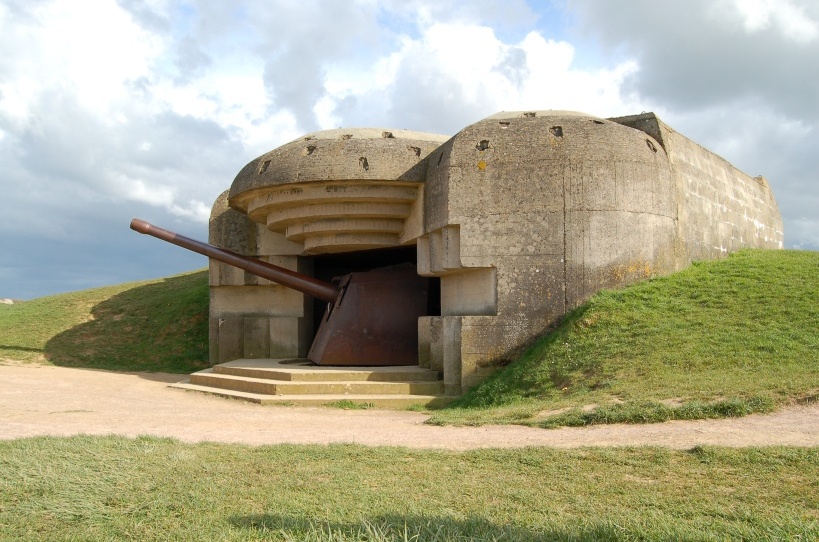 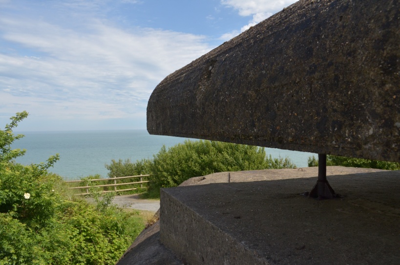 Scenic view of the four M272 gunnery bunkers, the mighty 150mm Skoda canon and a detail of the fire-control bunker with a view over the sea in front of Omaha Beach and Gold Beach. Photos: Barry van Veen (1 & 2) and Peter Bijster (3). The construction of the German coastal battery of Longues-sur-Mer started in September 1943. The battery’s command would be in the hands of the German Navy and was equipped as a standard naval coastal battery with one single M262 fire command bunker and four M272 gunnery bunkers each equipped with one piece of 150mm caliber gun with a maximum effective range of 19 kilometers. As defense against attacks from the land side the battery was surrounded with a barbed wire fence and several pill boxes, tobruks and ditches. As a defense against air attacks the coastal battery was equipped with several 20mm anti-aircraft guns and a search light. Obviously, because of its location between Gold Beach and Omaha Beach the allied forces felt much threatened by the battery of Longues-sur-Mer. At 05:30 AM on D-Day HMS Ajax opened fire at the coastal battery without causing much damage. Around 06:00 AM the battery itself opened fire at the command ship HMS Bulalo. Because of this threat, Bulalo had to weigh anchor in order to seek refuge. HMS Ajax and HMS Argonaut consequently opened fire at the battery again and after direct hits in the embrasure of two of the gunnery bunkers, the battery ceased fire at 08:45 AM. After having carried out clearing tasks the approximately 200 strong crew of the coastal battery resumed the firing in the course of the afternoon. Finally the French cruiser Georges Leygues succeeded in definitively silencing the battery. The coastal battery of Longues-sur-Mer was captured by British troops in the morning of the 7th of June, 1944. Between 26 June and 4 September an allied airfield with a runway length of 1,200 meters has been operating on the rock plateau. During this period the damage of the first gunnery bunker has been caused. An anti-aircraft gun stood on top of the gunnery bunker and its ammunition was stored in the bunker itself. By unknown causes the ammunition has exploded. | ||||||||||||||||||||||||||||||||||||||||||||||||||||||||||||||||||||||||||||||||||||||||||||||||||||
| Widerstandsnest 62 above Omaha Beach When the allied chiefs of command selected to have the invasion taking place in Normandy, quite soon it became clear that Omaha Beach had to be attacked. It is the only sandy beach between the mouth of the river Douve in the west and Arromanches in the east. With a length of almost 10 kilometers Omaha Beach is the longest stretch of all 5 landing beaches. For this reason the first landing wave would be existing of 2 divisions, the 1st and the 29th Infantry Division. Also Rommel knew, that if the allies would land in Normandy, they would have to attack Omaha Beach and he had many defenses constructed here. In total the defenders of Omaha Beach had 16 pieces of anti-armor guns and 85 machine guns. There was not one single centimeter of the beach which could not be covered with weaponry of all kinds of caliber. As soon as at 06:30 AM the landing doors of the landing craft were opened the fire of the German defenses burst loose. Many American soldiers were killed even before they could jump free from their landing craft. Others went under water and could not rise again because of the weight of their wet equipment. Again others cut the clasps of their assault jackets and rose back again. Without their equipment they had to cross 300 to 400 meters of flat, sandy beach. None of them was still capable of running, they walked or crouched with the tide in the direction of the bank of pebbles. On their way they took shelter behind the German barricades so the engineers could no longer clear lanes for the second wave of attack. Once arrived at the bank of pebbles, they sank to the ground completely exhausted. The losses were out of all proportions. 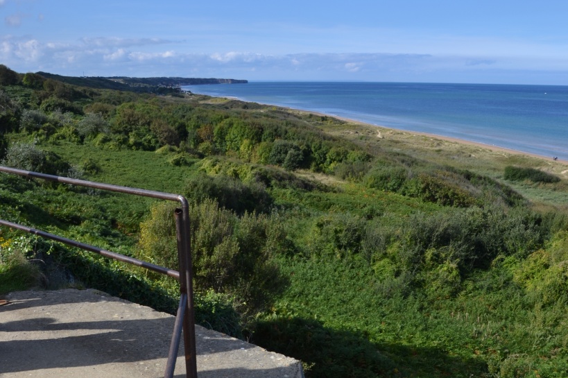 The view of the German defenders of Widerstandsnest 62 on Omaha beach. Photo: Peter Bijster. Widerstandsnest 62 was one of the German defenses from where the fire was directed at the American soldiers. From the monument for the 5th Engineer Special Brigade you have a good view of Omaha Beach. After you have well digested the situation, you move on to the American War Cemetery to the south-west. | ||||||||||||||||||||||||||||||||||||||||||||||||||||||||||||||||||||||||||||||||||||||||||||||||||||
| D | Waypoint | Normandy American Cemetery and Memorial | ||||||||||||||||||||||||||||||||||||||||||||||||||||||||||||||||||||||||||||||||||||||||||||||||||
| American Cemetery at Colleville-sur-Mer Viewed from the sea it looked like the attack on Omaha Beach had got stuck. Yet there was some progress. The engineers succeeded finally in clearing various lanes of about 50 meters wide in between the obstacles. The navy in the meantime had well noticed that the infantry could use their assistance. The destroyers approached closer to the coast and started to provide support with their canons aiming at visual range. Around 09:00 AM two small groups of Americans under the command of Spaulding and Dawson reached the top of the steep coastal wall on the spot where today the orientation table can be found on the American Cemetery. 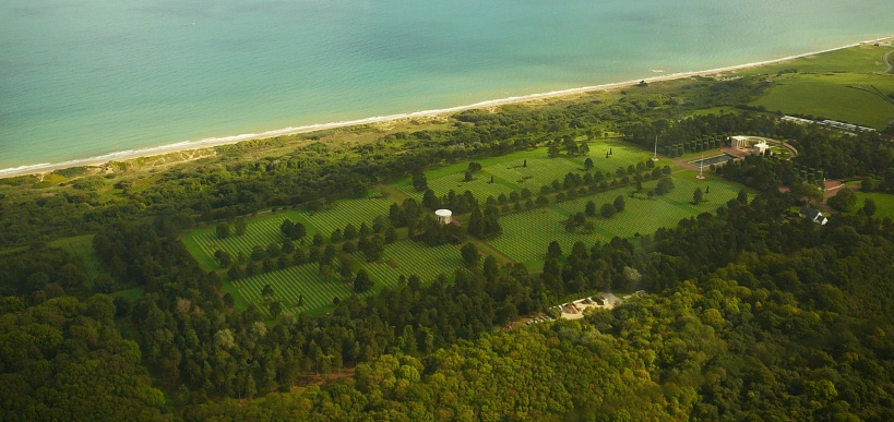 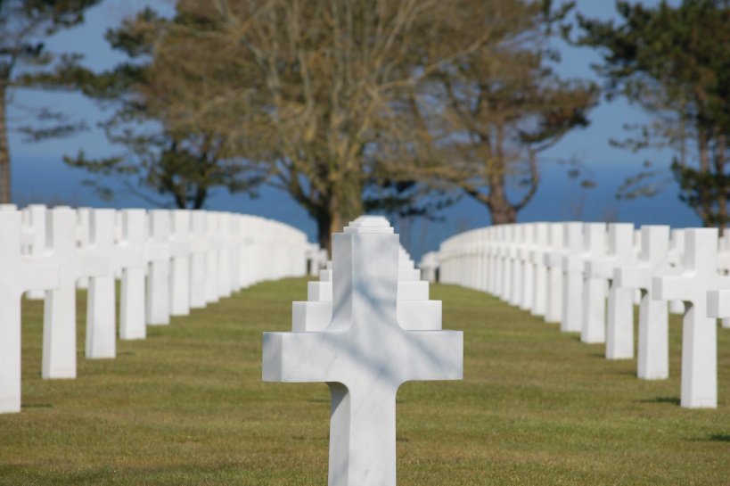 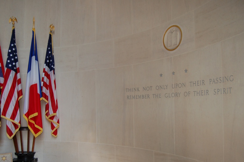 The American Cemetery at Colleville-sur-Mer seen from the air, endless rows of graves seemingly sinking away in the sea. And the interior of the chapel. Photos: Wim H. (1) and Barry van Veen (2) (3). Also at other places small groups of American soldiers commanded by natural leaders had discovered that on the steep cliff wall they were no longer under fire by the German Widerstandsnesten. This way the first infantry troops reached the coastal plateau in different places. The exits to the hinterland however were not yet cleared, the beach was crowded with vehicles and the German barrage kept going on uninterruptedly. Only at 14:00 PM the first of the exits had been freed and vehicles could start leaving the beach. Two more of the exits followed towards the evening, whilst the last two exits were still completely blocked. A concentrated counter attack would still have pushed the Americans back into the sea. The counter attack however did not come. The battle for Omaha Beach had been decided in the advantage of the Americans, although at a very high cost. Those who paid the ultimate price are buried here at the American Cemetery. Like all American cemeteries also the cemetery in Colleville-sur-Mer is being maintained in admirably good shape. The very special situation above Omaha Beach and the impressive visitors center make this cemetery one of the most visited sites in Normandy. | ||||||||||||||||||||||||||||||||||||||||||||||||||||||||||||||||||||||||||||||||||||||||||||||||||||
| E | Eindpunt | Pointe du Hoc Ranger Monument | ||||||||||||||||||||||||||||||||||||||||||||||||||||||||||||||||||||||||||||||||||||||||||||||||||
| The cratered moonscape of Pointe du Hoc Pointe du Hoc was the location of a German battery of six 155mm guns. The battery had been constructed in 1943 on top of a cliff which perpendicularly rose up to 40 meters high from the sea and originally consisted of six open concrete gun foundations. In 1944 however the construction of one fire-command bunker and six gun placement bunkers had started. In June 1944 the fire command bunker and two gun placement bunkers had been completed. Also the battery was equipped with ammunition bunkers and crew bunkers as well as with 20mm anti-aircraft guns. In view of its location between Utah Beach and Omaha Beach and the all destructive fire the canons were able to direct towards the landing beaches, the battery would have to be captured during D-Day. For this special assignment the Ranger Force consisting of the 2nd and 5th Battalion Rangers had been selected. In command was Lieutenant-colonel James Earl Rudder. Every landing craft of the Rangers had been equipped with 6 rockets with rope and anchor with which the Rangers could climb the cliff. During the actual attack only a few of the rockets reached the top of the cliff. A lucky strike was, that during the preceding bombardment part of the cliff had collapsed which made the climb much shorter. Within five minutes after the landing the first Rangers had arrived on top and ten minutes later also the remainder of them succeeded. 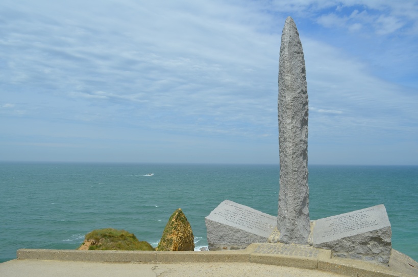 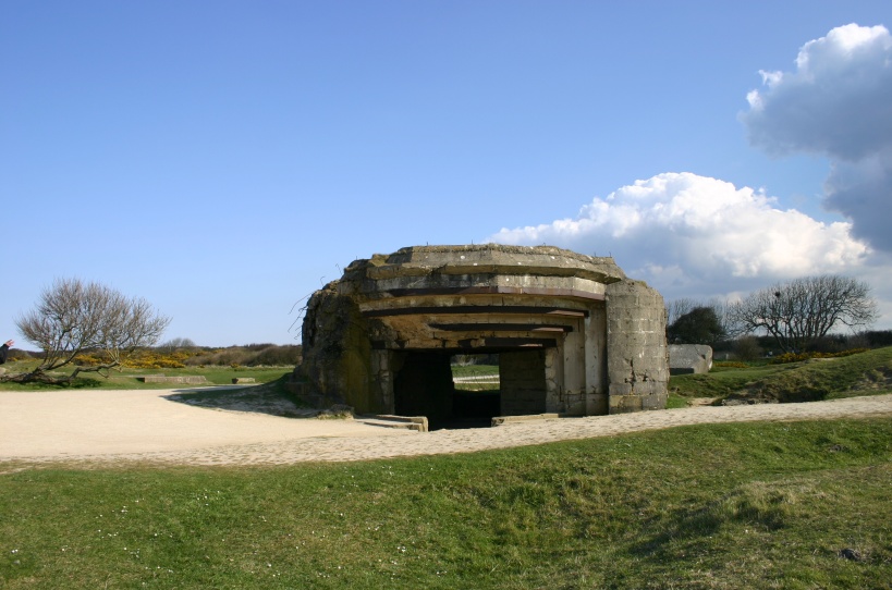 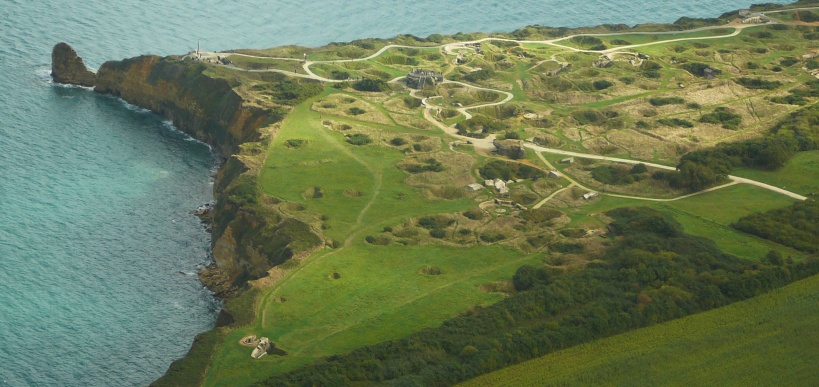 The Ranger Monument, one of the bunkers destroyed by the bombardment and the steep cliffs with the moonscape of Pointe du Hoc seen from the air. Photos: Barry van Veen (1), Jeroen Koppes (2) en Wim H. (3). The Rangers reorganized after the climb in one of hundreds of large bomb craters and prepared to capture their targets. Each and every platoon had the specific task to eliminate one special gun placement. Soon it appeared that the guns were no longer in the battery. Only here and there a few telephone poles stuck from the gun placement bunkers. This had escaped the attention of the intelligence forces. Towards 08:30 AM the Rangers discovered however in a fringe of the wood five of the six guns which had originally belonged to the battery. They were ready for use and there was enough ammunition available. The Rangers hesitated not a second and demolished the guns with thermite grenades. The threat, the battery had been for the landing beaches, had been withdrawn. Text Source: Pieter Schlebaum, Jeroen Niels and Barry van Veen Photo source: Peter Bijster, Wim H., Jeroen Koppes, Jeroen Niels and Barry van Veen Translation: Fred Bolle | ||||||||||||||||||||||||||||||||||||||||||||||||||||||||||||||||||||||||||||||||||||||||||||||||||||
Looking for reliable information or news facts about WW2? Do you want to create your own battlefield tour to sights of wars from the past? Or are you interested in war medals and their recipients? TracesOfWar.com tells you more!
More information

© STIWOT, 1999-2025. All rights reserved. Privacy statement, cookies, disclaimer and copyright